Jump to content

Wildfire Prevention
Using Sensors & Data

LORIOT Verso Solutions

Wildfire Prevention
Using Sensors & Data

Wildfires grow more frequent and severe. Proactive protection is essential. Our IoT solution combines real-time sensor data with intelligent algorithms to predict risks and prevent disasters before they start.

Managing forests effectively against wildfire threats is a challenge, especially when multiple stakeholders (farmers, tourist sector, forest department, …) with conflicting interests are involved.

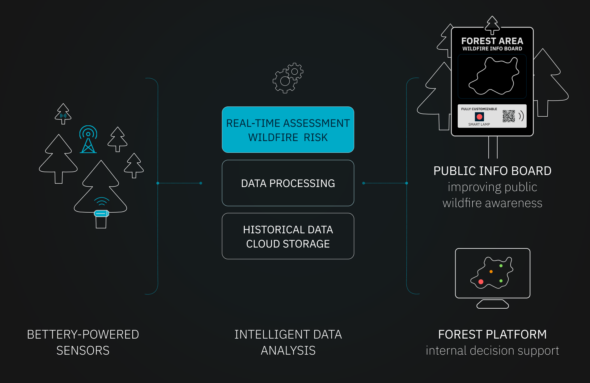
With our solution we enable the transition from general forest restrictions and seasonal fire bans towards a more optimized, real-time, and localized intervention for predicting and preventing wildfires.

Benefits


Time

Anticipated
Response

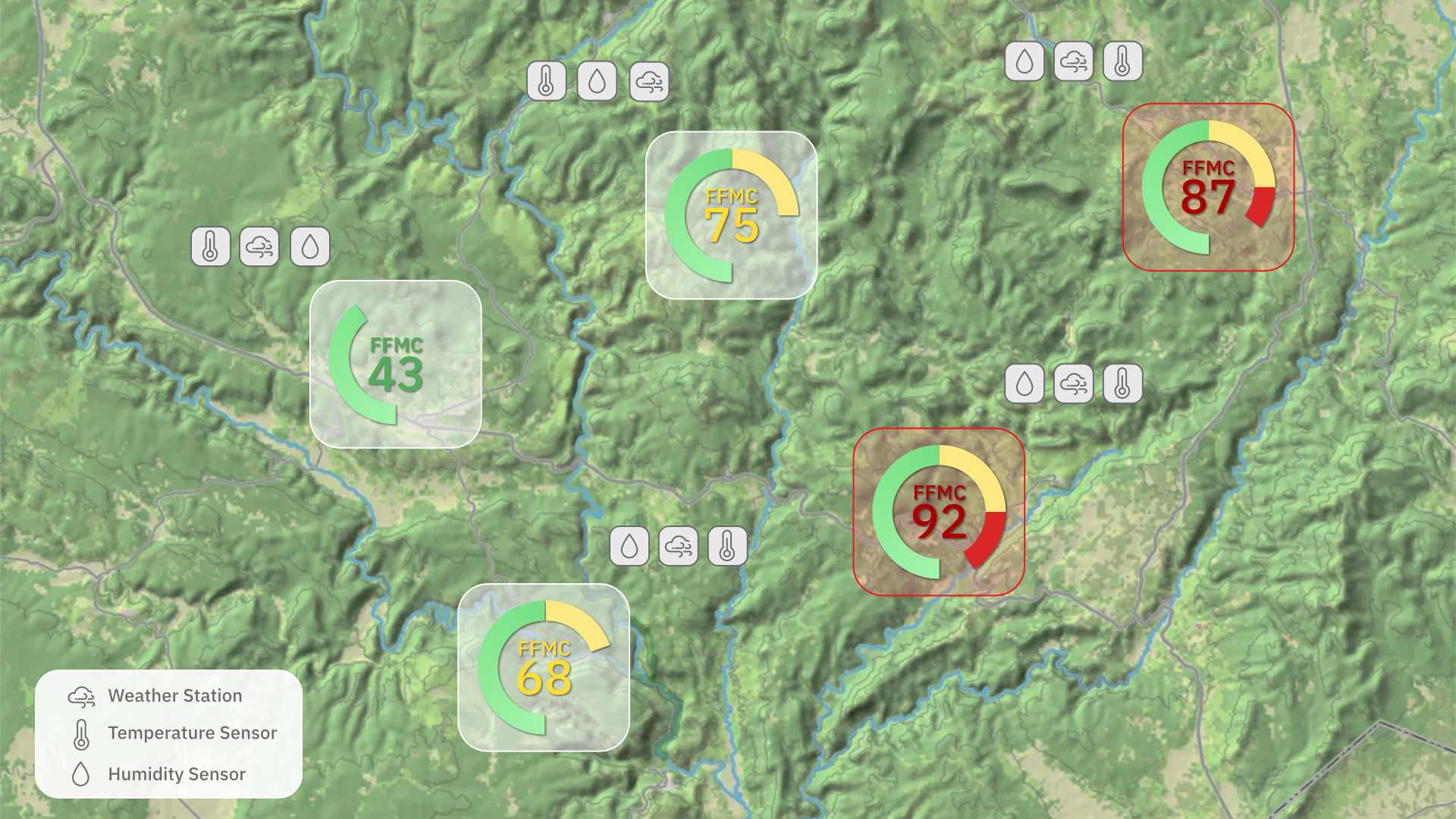
We continuously monitor weather and climate conditions to trigger preventative action. Reduces response times and streamlines coordination during high-risk periods.

Time

Objective
Decision-Making

Our system provides verifiable metrics that replace guesswork with objective data. This ensures fast, efficient activation of preventive measures based on reliable risk analysis.

Consultancy

Public
Awareness

Communication is key when it comes to public awareness. The data is not just relevant for internal decisions but is used in public informative displays to keep everyone informed.

Wildfire Prevention Dashboard Example


How it works?


  1. SENSOR MEASUREMENT

    By installing environmental sensors in your forest area we capture climate and soil data that influence the risk of wildfires, such as temperature, relative humidity, wind, or precipitation.
  2. REAL-TIME ANALYSIS

    Thanks to highly energy-efficient and long-range wireless technology, the sensor data is transmitted in real-time to the cloud.

    With sensors directly placed in the relevant forest areas, our system provides a hyperlocal risk and alert analysis. Integrated intelligent algorithms analyze the incoming data points, structure the information and calculate relevant wildfire risk indexes for your organization (e.g. FFMC).
  3. INSIGHTS & PUBLIC DASHBOARD

    The results and insights are made available in a digital dashboard, which can be used for internal decision making and a better understanding of the wildfire situation.

    The dashboard displays multiple environmental measurements, detailed analysis and forecasts, all linked to specific forest areas.

    Furthermore a public dashboard (e.g. remotely controllable fire risk gauge, fire risk traffic lights, QR codes or public information board) is available to keep citizens and tourists informed about the current wildfire situation and associated risk.

    Maintaining public awareness of political actions is essential, and this dashboard serves as a key tool for that transparency.

    When people can see the data themselves, they better understand the ‘why’ behind safety measures, leading to greater acceptance and cooperation.
Wildfire Prevention Technology Infrastructure Graph
Book a Free Call

Michael Mitter

State Forestry Director
Salzburg, Austria

Use case

“With the measurements of the weather data and soil moisture as well as the processing in the dashboard, we, as the forestry authority of the province of Salzburg, can point out the forest fire risk potential in different regions in a differentiated and targeted manner. The cooperation with LORIOT was extremely professional and uncomplicated from the very beginning. We are convinced that we have found a good partner for the implementation.”

FAQ


  • How can I estimate the numbers of sensors needed for my forest area?
    Every project is different and the number of necessary sensors varies depending on topology and local climate conditions. To be as cost-efficient as possible, sensors are placed at strategic locations to cover as many km² as possible.

    From a technological perspective there is no restriction on the minimum or maximum area that can be covered.
  • How much does the solution cost?
    The solution is adaptable to various budgets and project sizes. A minor project is as evenly possible as a state wide rollout. Pricing varies accordingly.
  • Is it necessary to have cellular network coverage in the forest area?
    No. Our wildfire solution is technology independent, even hybrid solutions, combining different technologies like LoRaWAN (independent of mobile coverage) and 5G, are possible. This infrastructure allows for data acquisition from every sector of the forest; minimizing costs and maximizing your utility.
  • Can the solution be integrated with already existing systems?
    Yes, an integration in Smart City or other platforms is no problem and can be adapted to your needs.
  • What is the typical timeframe for the end-to-end implementation of the system?
    Our extensive global network enables us to set up your wildfire prevention system in a fast and smooth manner. Minor projects can be set up in just a few weeks.

    Bigger projects can take a little longer, due to the increased communication and organization effort of various stakeholders.
  • Do we need to do the sensor maintenance ourselves?
    Depending on your needs we can also handle the continuous sensor maintenance after the initial installation of the system.
  • What is the FFMC (Fine Fuel Moisture Code)?
    The FFMC is a numerical index that estimates the moisture content of pine needles, leaves, twigs, dried grasses, etc. found on the very top layer of the forest floor.

    Because these materials are thin and light, they dry out very quickly, making them the most inflammable parts of the forest. Therefore, the FFMC is the most sensitive indicator of how easily a fire can start and how fast it will spread in its initial stages. It is part of the overall FWI (Fire Weather Index).
  • How does the technology behind the solution work?
    If you want to learn more about the technological aspects of our solutions, please read here.


Interested in preventing wildfires in your forest area?


Let’s discuss how we can tailor this innovative wildfire prevention system to your specific project.